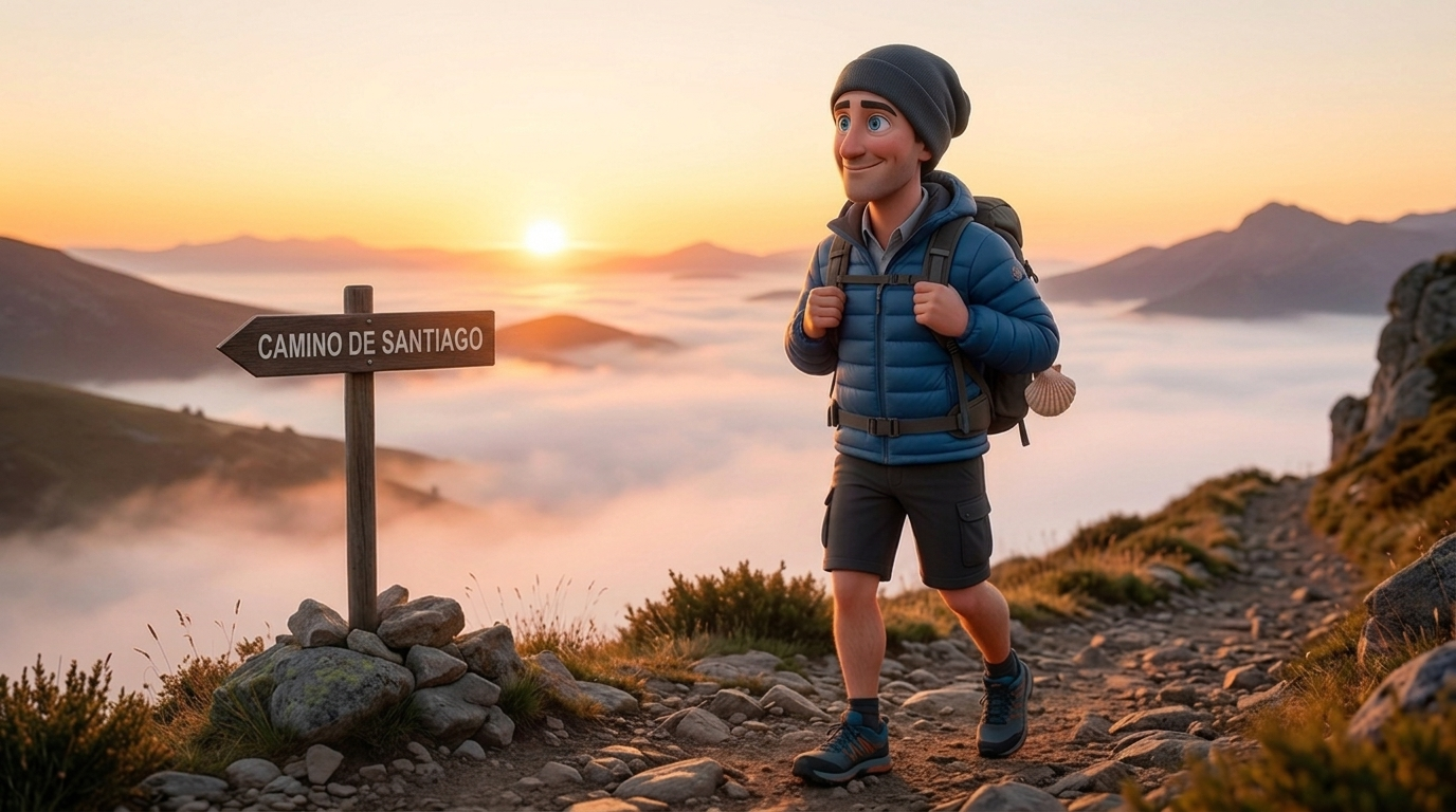
I leave for the Camino San Salvador in less than a week
120km, five stages, and a pass at 1,560m between me and Oviedo. Here's how I planned the Camino San Salvador before setting out on August 22, and why it finally connects to the Primitivo.
I leave for the Camino San Salvador on August 22. This post is not a trip report. I haven't walked a single kilometer of it yet. It's everything I've pieced together in the last few weeks of planning, so that if you're staring at the same route on a map right now, you've got somewhere to start.
The travel plan is simple enough. I'm flying into Madrid, then taking the train up to León, and staying the night there before setting out fresh the next morning. Before I take a single step, I need to pick up my pilgrim credential in León, the little passport that gets stamped at every albergue along the way. I'm using that same credential all the way to Santiago, through the San Salvador and straight onto the Primitivo.
Why the San Salvador
Most people walking to Santiago never touch this route, and I get why. The San Salvador isn't really a Camino to Santiago at all. It's a connector, 120km running from León up and over the Cantabrian mountains to Oviedo, where the Camino Primitivo actually begins. You're not walking toward St. James's tomb on this one. You're walking toward the Cathedral of San Salvador in Oviedo, where King Alfonso II had Christian relics moved centuries ago to keep them out of reach during the Muslim conquest. Different destination, different reason to walk, and that's part of what pulled me toward it.
I'm not religious. But I pay real respect to history and culture, and walking through both is most of why I do this at all. Medieval pilgrims apparently argued about this exact detour, and one line survived eight hundred years of that argument:
"Quien va a Santiago y no al Salvador, visita al criado y no al Señor."
"He who goes to Santiago and not to the Savior, visits the servant and not the Lord."
I'm not walking to settle a theological ranking between a servant and a Lord. I'm walking because a saying that pointed still gets repeated eight centuries later, and that alone tells you how much this connector used to matter.
The other part is practical. If you're already on the Frances and want to pick up the Primitivo, which most people consider the oldest and one of the toughest Caminos, the San Salvador is how you get there on foot instead of a train from León to Oviedo. Five days connecting two of the most historic routes in Spain, with a mountain pass over 1,500m in between. That's not a detour. That's a route in its own right.
Why now, and why I almost skipped it
Last year I walked the Camino del Norte, up along the northern coast, and I passed close enough to this whole corridor that I could feel it pulling at me. I didn't detour. I kept walking the coast because that's what I'd planned, and you can't chase every interesting trail branch or you'll never actually finish anything. But I remember standing somewhere around Asturias thinking about León and Oviedo and the mountains between them, and telling myself I'd come back for it.
This August is that comeback. I've got the San Salvador booked, and I'm walking straight into the Primitivo afterward from Oviedo. It's the same instinct that got me writing about this trip back in June, when it was still two months out and mostly a collection of half-formed thoughts I was catching in Reflections before they disappeared. Now it has a date and a set of stages, and in eleven days I'll actually be on it.
How I planned it
I did most of my planning in two places. For questions I couldn't answer myself, things like where the albergues actually are versus where the guidebooks say they are, I used My Camino Guide, the tool I built for exactly this kind of planning. It's faster than digging through forum threads from 2019 for an albergue that may or may not still be open.
For the hard numbers, the actual stage-by-stage distances, elevation, and terrain, I leaned on Stingy Nomads' San Salvador guide and their walking stages PDF. It's the most detailed breakdown of this route I found anywhere, and I mapped the elevation from their stage data to give me an idea of what to expect each day.
The five stages
Five days, 120km total, and just over 3,000m of accumulated ascent packed into the middle three days. León is the only night I've actually booked. Everywhere else below is a rough plan, the places I'll probably aim for, not reservations, because I like staying spontaneous on a Camino and seeing what pulls me each day, especially if I'm feeling good and want to stretch a stage further than planned.
Day 1: León to La Robla, 27km
León sits at 837m and the route holds mostly flat for the first eight kilometers before climbing steadily to a high point of 990m. Total ascent is 485m, descent 361m. Half the day is asphalt, so it's a gentler warmup than what's coming.
For water and a coffee, I'm breaking at Carbajal de la Legua around the 6km mark, then again at Cabanillas near 17km if I need it. The municipal albergue in La Robla is closed, so if I stop there for the night, Pensión Mundo is the rough plan.
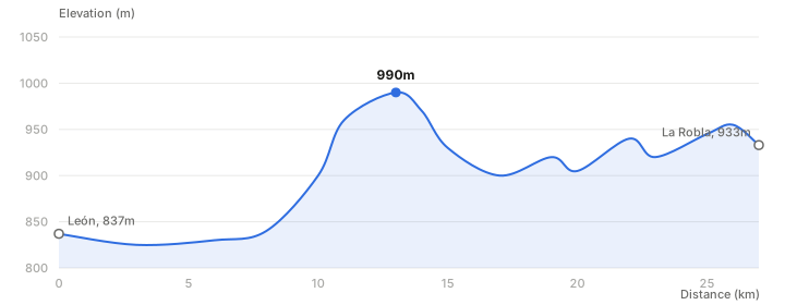
Day 1 elevation profile, León to La Robla. The climb starts around kilometer 8.
Day 2: La Robla to Poladura de la Tercia, 23.5km
This is where the mountains start for real. Ascent jumps to 680m against 400m of descent, and the max elevation climbs to 1,467m. The Stingy Nomads guide splits this day into two halves, La Robla to Buiza and then Buiza to Poladura, because the second half is where the real climbing happens.
La Pola de Gordón at 8.6km is the last proper town on this stage, pharmacy and shops included, so that's my resupply stop before Buiza and the long climb to Poladura. For the night, the rough plan is the municipal albergue in Poladura, or Hotel La Posada El Embrujo if it's full or if the day's beaten me up more than expected.
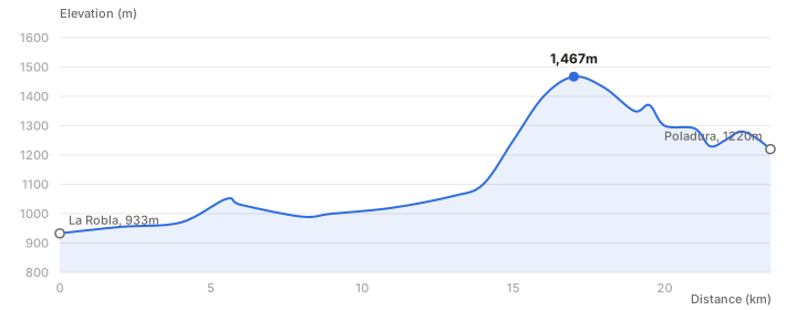
Day 2 elevation profile, La Robla to Poladura de la Tercia. The steep section starts after Buiza, around kilometer 14.
Day 3: Poladura de la Tercia to Pajares, 14km
Short on distance, brutal on everything else. 605m of ascent and 797m of descent crammed into 14km, with the route's highest point at 1,560m. This is the stage every guide flags as the toughest day on the San Salvador, and looking at the profile, I believe it.
There's a restaurant at Puerto de Pajares, right near the top of the pass around the 9km mark, and that's where I'm planning to eat before the knee-jarring drop into Pajares. The albergue in Pajares is small, so the rough plan for the night is that, or Pensión El Mirador if it's already full.
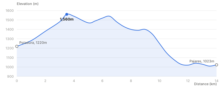
Day 3 elevation profile, Poladura de la Tercia to Pajares. The route's highest point, 1,560m, comes early.
Day 4: Pajares to Pola de Lena, 24km
Pajares sits at 1,000m and it's mostly downhill from there, but "mostly downhill" over 24km still means 655m of climbing wedged between drops. Total descent on the mountain route is 1,390m. Somewhere around kilometer 6 the route splits between a mountain path and a road option, and I'm planning to take the mountain path since I still have legs at that point.
Campomanes, around 17-19km in, is the last proper town on this stage, with a pharmacy and an ATM, so that's my resupply stop before the final push. The rough plan for the night is the Albergue de peregrinos San Martín in Pola de Lena, though this is also the stage with the biggest incentive to just keep going if I'm feeling strong.
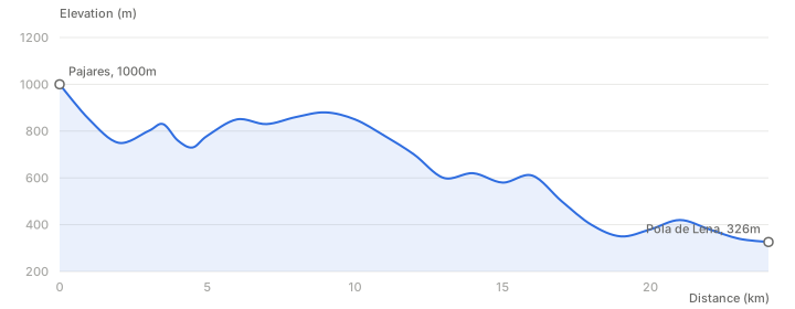
Day 4 elevation profile, Pajares to Pola de Lena. The steepest drop comes in the final third, after Herias.
Day 5: Pola de Lena to Oviedo, 32km
The longest day, and the one that finally puts Oviedo's cathedral in sight. It's gentler than the middle stages, 630m ascent and 696m descent with a max elevation of only 406m, but 32km on tired legs after four mountain days is its own kind of hard.
Mieres del Camino, around the 13-15km mark, is the biggest town on this stage and where I'm planning a proper lunch, with one more resupply at Olloniego before the last 9.5km into Oviedo. Oviedo is the one fixed point on the whole trip, so the rough plan is to finish at the Albergue de peregrinos El Salvador, right by the cathedral, which feels like the right way to close out this route before the Primitivo picks up.
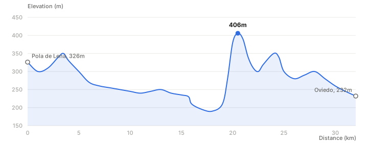
Day 5 elevation profile, Pola de Lena to Oviedo. The last real climb of the route sits around kilometer 20.
What I'm bracing for
Day 3 is the one I keep coming back to. 1,560m is nothing next to routes I've done in the Andes or Nepal, but the descent into Pajares drops nearly 800m in a handful of kilometers, and that's the kind of grade that wrecks knees, not lungs. I'm packing poles for this trip specifically because of that stage.
The other thing every source agrees on is that facilities are thin. Towns are spread far apart, some albergues listed in older guides have closed, and a few of the restaurants marked on the stage sheets keep what one guide politely calls "random open hours." I'm carrying more food between towns than I would on the Frances, where you're never more than a couple of hours from a bar with a menu del dia.
I haven't walked a step of this yet, so take all of this as a plan, not a report. Ask me again in September.
Then, the Primitivo
Oviedo isn't the end. It's the start line for the Camino Primitivo, the route Alfonso II supposedly walked first, over a thousand years ago, before there was a Camino Frances to make everything after it easier. Finishing the San Salvador and turning straight onto the Primitivo closes a loop that's been open since last year's Norte, when I walked past all of this and told myself I'd be back.
I'll be posting as I go, and if you want to follow along or plan your own version of this route, hit subscribe.
Subscribe
New posts on AI, developer relations, photography, and the odd long walk, straight to your inbox. No spam.